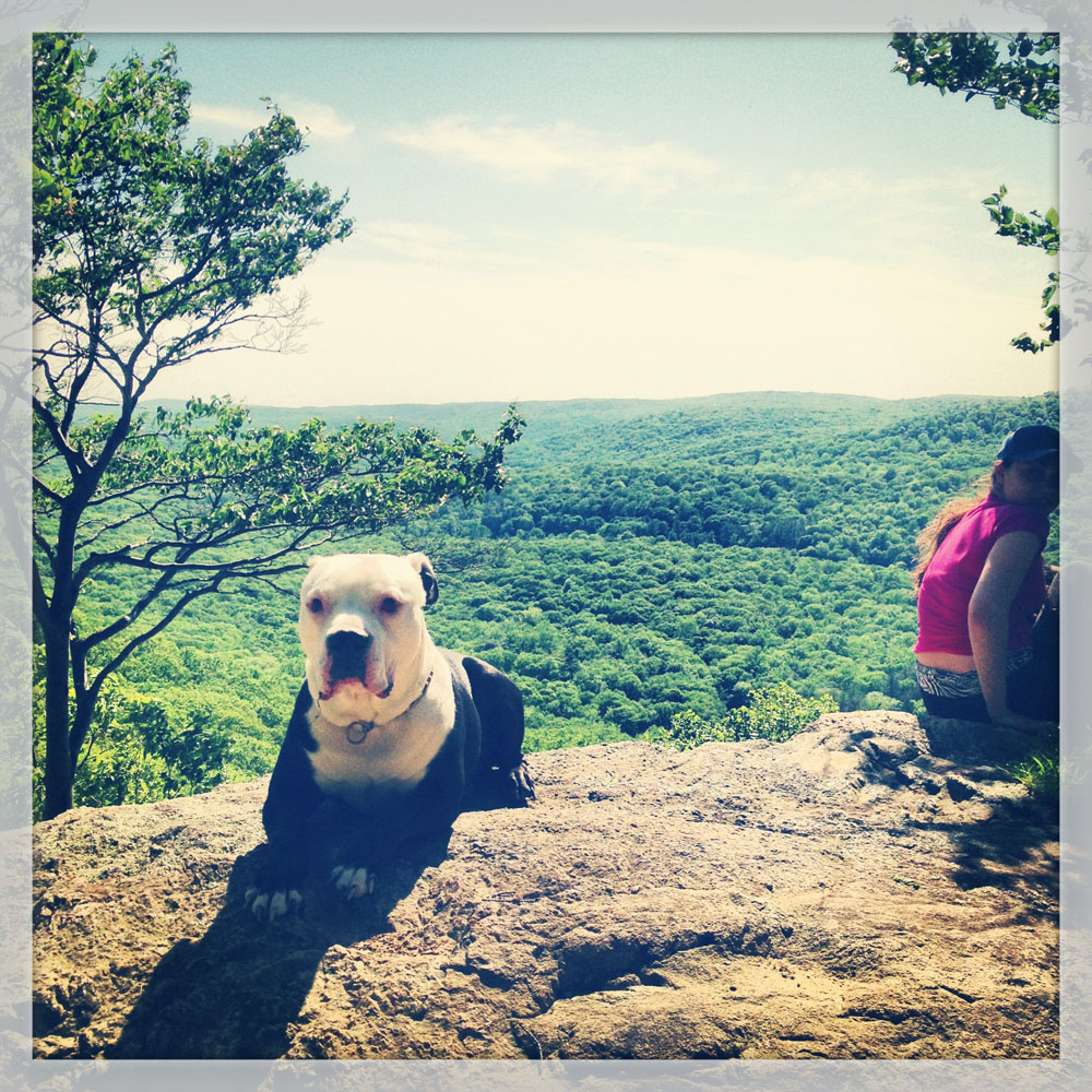
A dog takes a break on the Ramapo-Dunderberg trail on West Mountain. The Timp-Torne Trail and the R-D Trail may be combined for a loop hike that will take you all day, and afford you great views of the Hudson River and the New York City skyline.
Trails from the Anthony Wayne Recreation Area to West Mountain and The Timp
Park at GPS: 41.29089 N, 74.02420W.
I think we all have our favorite spots to hike in Harriman, but it’s hard to narrow them down. I thought I’d post five of my favorite areas, with downloadable maps of the sections I love to hike These are in no particular order.
West Mountain
When I first got the trail maps for Harriman State Park, it was the Timp-Torne Trail that caught my eye first, and it never disappoints. In parts grassy, or rocky, or wooded, the loop that includes the blue-blazed Timp-Torne Trail and the red-blazed Ramapo-Dunderberg trail includes plenty of varied terrain, great views of the Hudson River, a historic lean-to shelter and so much more.
Use our map to plan your hike. The best views are found along the Timp-Torne and the Ramapo-Dunderberg trails, so a spectacular loop hike can be made with these two favorites.
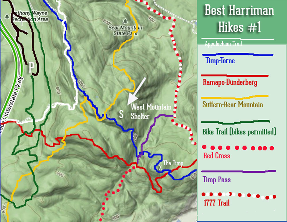
Park at the GPS 41.29089 N, 74.02420 W: Anthony Wayne Recreation Area — Exit 17 off the Palisades Parkway — to access some of the best hikes in Harriman State Park, NY. Download this map as a PDF with the link above.
Parking at Anthony Wayne Recreation area, you can follow the old ski trail (marked in green on our map) to its intersection with either the Appalachian Trail (white) or the Ramapo-Dunderberg trail, and make a loop of it.
Use the Timp Pass Road (purple on our map) to shorten your loop, or hike the Ramapo Dunderberg Trail to its intersection with the Timp-Torne, and take in the views of the Hudson River and the New York City skyline from “The Timp” (marked on our map).
Bring a lunch and enjoy views of New York City from the West Mountain shelter, a great spot to rest and meet thru-hikers on the Appalachian Trail.
Remember: There are many unblazed, unmaintained trails or unmarked woods roads that crisscross Harriman State Park and Bear Mountain. Don’t divert onto them without a complete map, or without a familiarity with the trails — you may get lost.
Get There
GPS: 41.29089 N, 74.02420W (Parking is in the Anthony Wayne parking lot)
Take the Palisades Parkway north to Exit 17 — the Anthony Wayne Recreation Area — and park in the furthest (southernmost) parking lot, at the edge of the woods. Follow the bike trail (green trail on our map) to the color-blazed trails.
You can also order the official (and indestructible) New York New Jersey Trail Conference Map Set for Harriman State Park and Bear Mountain State Park. These are must-haves if you plan on exploring all that Harriman has to offer. Follow the links on the right to purchase.

Many thanks for sharing this hidden gem. Loved the rocks on the blue trail and the views of the river on the white. Thanks!
Do you know how many miles this hike is and is it ok for dogs?
I did this with my pit bull today and he loved it. It may be difficult for a small dog. Also start from the north end of TT and work your way south. It’ll be a challenge, but its easier for the dog.
How many miles is it if you shorten with the timp pass road?
We did this yesterday, but got confused about where we were starting, and ended up staying on the green trail for too long, until it intersected with the yellow. We then took this back up to the Timp-Torne and followed the ridge north and around to the top of the parking lot again. I’m curious how many miles this ended up being – any ideas on that?
It was amazing though – that section of the yellow trail has strenuous rocks to climb up – we weren’t sure we could do it but it was fantastic, and we were rewarded with an awesome view at the top. We were with 2 10-year-olds who loved it. Highly recommend this!
Picturing a dog without a lease is misleading and wrong. Owners of unleased dogs are in violation of park rules, and subject to fine. Your trail map around the Timp Torne is incorrect and misleading.
Hi! I read that the Anthony Wayne Rec area is closed for a COVID testing site. Do you know if the parking lot still open to access this trail? If not, is there a nearby lot? Thanks in advance!
Anthony Wayne isn’t open for hiking parking until COVID is over