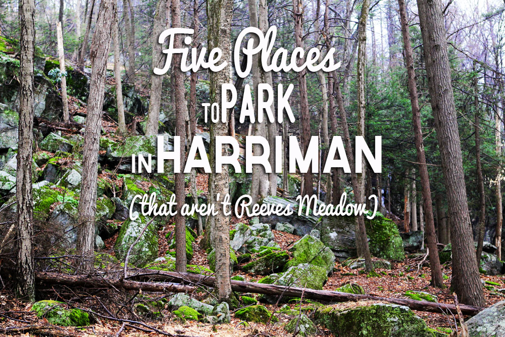
When you see the cars lined up in front of the Reeves Meadow Visitor Center, remember: the park is the size of almost three Manhattans! The trick to finding your solitude, and a handy parking spot, is in going to some of the other parking areas. Here are five suggestions.
Memorial Day Weekend: Stay Away from Reeves Meadow!
This coming weekend is Memorial Day weekend, and the weather looks like it’s going to be clear and beautiful. That means there will be a long, long line of cars — close to 200 — parked up Seven Lakes Driver near the Reeves Meadow Visitor Center.
Don’t be fooled into thinking that the only trails in the park begin and end at the Reeves Meadow Visitor Center! Get the trail maps and spend some time studying them. Once you see that the park is criss-crossed by an incredible network of trails, built long ago by the Trail Conference and maintained lovingly ever since, you’ll stay away from Reeves Meadow on busy weekends.
So here are five other places to leave the car in Harriman State Park, with suggestions for what trails to take when you’re there. Remember that if you’re spending the night at one of the shelters, you are allowed to leave your car in a legal parking area overnight.
And remember to have a map, and preferably two: a paper map in your hand, and a digital map on your smartphone. Why both? Because some get lost with a paper map in Harriman, and you can lose battery power on your smartphone.
Beginning of the Victory Trail, at one of the Black Rock Mountain parking areas along Route 106.
Maps:
1. The Trail Conference trail maps, of course, are the gold standard for mappiness. Get them at any outdoor shop in the area, at the Palisades Visitor Center and Bookstore,
2. ….and/or download the free PDF map app for smartphone, called Avenza. From inside the app, go to the “shopping cart” symbol and find and purchase the two maps for Harriman and Bear Mountain. They’ll live on your phone, and you can see exactly where you are on the trail. Tip: bring a separate phone charger/power supply that fits in your pocket, so you don’t run out of juice.
2. You can also plan your route using OpenStreetMap, and the OpenMap Pro app for iPhone (though it’s not as detailed as the Trail Conference maps for Avenza).
Park Here. And Here.
Anthony Wayne Recreation Area (GPS 41.289997, -74.024216):
Two humongous parking areas give you access to the crazy views along the Timp-Torne trail, or an all-day hike over to Bear Mountain, five miles to the northeast. You can also loop over to little-visited Queensboro Lake and Turkey Hill Lake.
Type: Large, very large parking areas — two of them. Room for hundreds of cars.
How to get there: Take the Palisades Parkway north or south to Exit 17 (Anthony Wayne Recreation Area). Drive through the first parking area and into the next one to be closer to the trailheads.
Favorite Routes from here: Timp-Torne trail along the top of West Mountain is one of the most scenic routes in the park, as is the Ramapo-Dunderberg trail segment that leads to Timp Pass. Gorgeous.
Features: West Mountain Shelter; Bear Mountain; Horn Hill Bike Trail; Queensboro Lake access.
Closest place to pick up a cold drink or map: Stop at the Visitor Center just south of Exit 17, literally in between the lanes of the Palisades Parkway (it’s a former rest area). You can pick up maps for not just Harriman and Bear Mountain, but other area parks as well, where the trails are maintained by the Trail Conference. Snacks, drinks, souvenirs, books, a pay phone and public restrooms are available as well. When you’re done hiking, you can stop in at the Bear Mountain Inn for a drink, a lunch or dinner, or just an ice cream. Or, it’s just a 15-minute drive to the Garrison Cafe: cross the Bear Mountain Bridge and head north up the Hudson on Route 9D for 5.2 miles, until you come to Garrison Cafe on the left. It’s one of my favorite post-hike cafes.
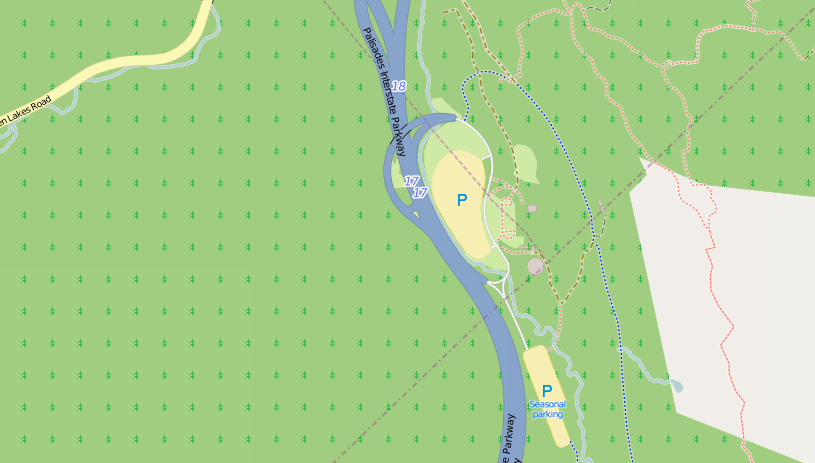
The Anthony Wayne Parking Area, off exit 17 on the Palisades Parkway. Map © OpenStreetMap contributors
Call Hollow Road Parking Area (GPS: 41.217999 -74.050747):
Three reservoirs and a shelter in this “quiet corner” of the park. The hike’s a little dull until you reach Second Reservoir, but then it gets good. Bring something to eat at its shore, and make sure you check out Big Hill shelter.
Type: Roadside pull-out. Room for several cars.
How to get there: From the Palisades Parkway (north or south) take Exit 14 onto Willow Grove Road. If you’re heading south, turn right onto Willow Grove; if you’re heading north, turn left onto Willow Grove. In .5 mile, turn left onto Call Hollow Road. Drive for a little under half a mile, and park on the right-hand side of the road, by the gate. There’s also a parking area that you’ll pass sooner, on the right. It offers access to the Long Path and a little cemetery.
Favorite routes from here: I like to hike up Woodtown Road, the uphill paved road that goes past the power station and dam of the First Reservoir, and take this all the way to Second Reservoir. Just before reaching the reservoir, I take the right-hand turn to follow the unmarked trail around the shoreline of Second Reservoir, and finally veer away from the lake to head toward Big Hill Shelter, one of my favorites. You can do the full tour of the waters by visiting all three reservoirs, plus Breakneck Pond, as well.
Features: Reservoirs, a shelter, firepower, old cemetery.
Nearest place to get a drink or snack before or after: There’s a gas station with a Dunkin’ Donuts in Willow Grove; from Exit 14, drive east on Willow Grove Road (away from the park) for about a mile. The gas station/snack shop/Dunkin’ Donuts is on the corner of Algonquin and Willow Grove Road.
Other: Big Hill Shelter sits atop Big Hill, with views to New York City. The shelter sleeps eight, but if it’s occupied when you get there, throw up a tent in the vicinity. Bring your own water, and pack out your toilet paper!
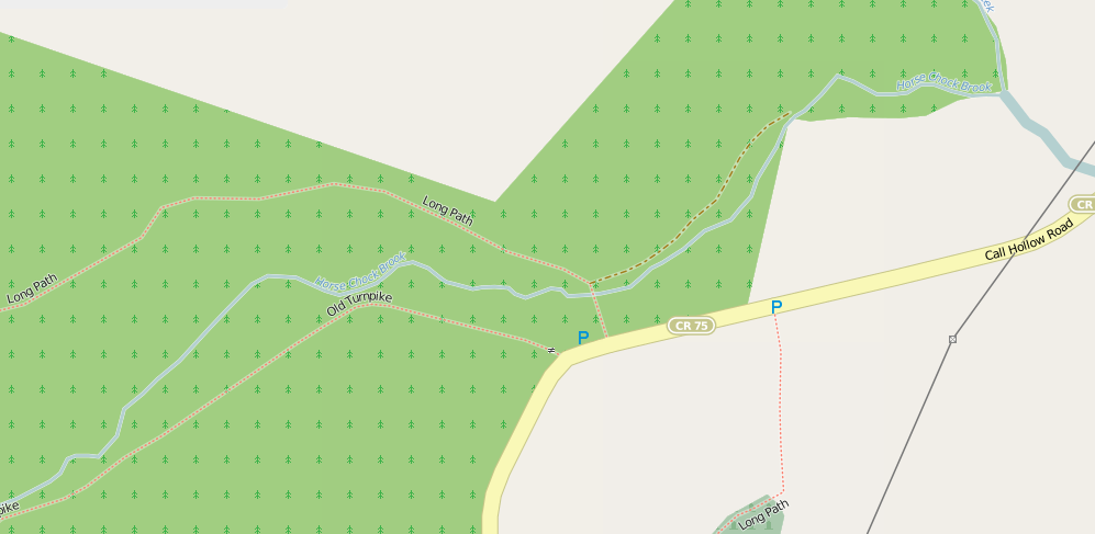
Call Hollow Parking areas, with access to the Long Path and the Three Reservoirs. © OpenStreetMap contributors
ORAK ruin parking along Gate Hill Road (GPS: 41.229914 -74.060818).
Another parking area that’s near the Call Hollow Road parking area, but this one gives you closer access to Upper Pound Swamp, Irish Mountain and the Fire Tower on Jackie Jones Mountain.
Type: Roadside pull-out; no signage. Space for about 10 cars, or more.
How to get there: Take the Gate Hill Road exit, Exit 15, off the Palisades Parkway, and head west into the park on Gate Hill Road (Route 106). Don’t get turned around on exit 15! It’s confusing and counter-intuitive, because the exit sweeps around on both sides, and you’ll think east is west. From the Parkway, drive for about 1.5 miles, then bear right to stay on Route 106 west. The parking area is less than a quarter-mile on the left.
Favorite routes from here: Heading north, you can follow the yellow-blazed Suffern-Bear Mountain trail over Irish Mountain, and then meet up with the unblazed trail that turns left toward Upper Pound Swamp, a quiet, pretty haven for birds and turtles, and some evidence of stealth camping near the water. You can also head south along the SBM trail, through the mysterious ORAK ruins, and up to the Jackie Jones fire tower — a good hike for kids.
Features: Pond, interesting ORAK ruins; fire tower.
Where to get a drink or snack, before or after: You can take Route 106 out of the park (head east) and, in 2 miles, it becomes Route 210 in the town of Stony Point. In another 2.4 miles, it meets Route N 9W at a T-junction, and you’ll find places to eat in the plaza across the street from that intersection, with more choices nearby. There’s pub food at Halligan’s, open 7 days a week.
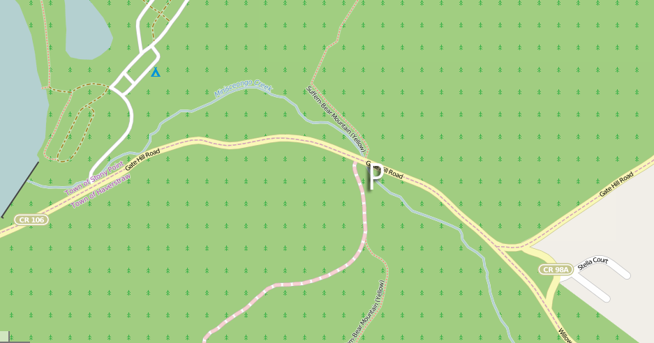
ORAK ruins parking area, off Route 106. Map © OpenStreetMap contributors
The Black Rock Mountain Lots (Route 106) (GPS: 41.227851 -74.148977; GPS 41.230223 -74.139894; GPS 41.235037 -74.148933)
One of the best areas in the park to explore, to feel like you’ve escaped the city and are somewhere wild.
Type: Three roadside pull-out lots; signs indicate hiking and trails. Space for more than 10 cars.
How to get there: Take I-287 west to Exit 15A (Sloatsburg/Suffern) and turn left at the bottom of the ramp onto Route 17 north. Follow 17 north through Sloatsburg and Tuxedo for about 8 miles, to a traffic light intersection with 17A. Turn left at the light, and immediately turn right to go over the bridge onto Route 106 through the park. Drive east for 2.5 miles, and then start looking for these three parking areas (they’re labeled with a “P” on the Trail Conference paper and digital maps, and the OpenMaps Pro app maps).
Favorite routes from here: This is such a pretty areas of the park, and almost any way you go, on any of the trails, will make you happy. Hike Island Pond Road up to Green Pond for a half-day hike or less; get on the Ramapo-Dunderberg trail south toward Tom Jones Shelter (my favorite) or north, towards Bald Rocks shelter. Find a hidden shelter along the white-blazed White Bar Trail overlooking Lake Stahahe. Any of these routes are rewarding, and you can’t go wrong — just make sure you grab a map! If you’re driving through Tuxedo to get here, stop at the public library in town — they sell maps from behind the front desk.
Features: Everything. Three shelters (two on the maps, one not!), streams, ponds, abandoned mines, viewpoints. A top area of the park.
Where to get lunch or supper afterwards: Head back into Tuxedo and look for the Tuxedo Junction Inn opposite the train station and a little south. It’s easy to miss it because signage is minimal and it’s set back in a parking lot, but when you find it, you can get a beer and basic pub food. Or, keep driving into Sloatsburg, a little farther south along Route 17. Rhodes North Tavern has a good post-hike menu (and they do a great pre-hike breakfast out on the back deck, as well.)
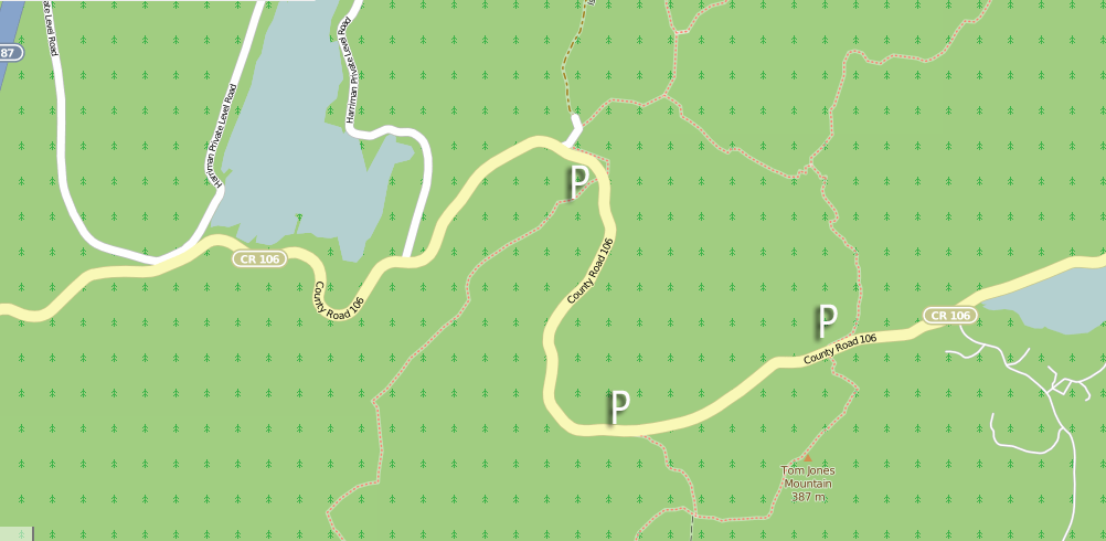
Three Black Rock Mountain parking areas, with access to shelters, views and features along one of the Ramapo-Dunderberg Trail’s most picturesque stretches, and Lakes Skenonto and Sebago. Map © OpenStreetMap contributors
Turkey Hill Parking area (GPS: 41.316489 -74.050856).
At the top of the park are three lesser-visited lakes: Turkey Hill Lake, Queensboro Lake and, further west, Lakes Massawippa, Te Ata, Barnes and Lower Twin. This parking area is of ample size and you can fashion hikes of different lengths from the one parking area. If you have dogs who love to swim, but tend to overheat getting to the trails, the trail from this parking area affords easy access to the shores of Turkey Hill Lake.
Type: Paved horseshoe-shaped drive dedicated to hikers using the Long Path and routes to Turkey and Queensboro. Plenty of room for parking, the lot is rarely filled. Could probably hold more than 50 cars.
How to get there: Route 6 spans the width of the country, but you can reach this parking area from either I-87 to the west, Bear Mountain traffic circle to the east (stay away from Bear Mountain on busy summer weekends!) or the Palisades Parkway. From 1-87: Get off at exit 16 in Harriman, and take Route 6 east for a couple miles to the parking area. From Palisades Parkway: Take Exit 18 towards Route 6 west; go through the Long Mountain Circle and onto Route 6/Long Mountain Parkway; drive 1.4 miles. The parking area is on the right. From Bear Mountain Traffic Circle: Follow Route 6 west for 4.2 miles; the parking area is on the right.
Favorite routes from here: I like to hike the Long Path to the red-blazed Popolopen Gorge Trail, and then down to Turkey Hill Lake. If you keep following the Popolopen Gorge Trail, you’ll eventually reach the dam over the eastern edge of the lake (stay on the trail to cross the stream below). Look for Summer Hill Road, an abandoned woods road that traces the eastern shore of Turkey Hill Lake, right up to the north end. It’s grassy, quiet, and there are some sweet picnic spots right up to the edge of the lake. There’s evidence of stealth campsites all the way to the end of the lake, and why wouldn’t there be? It’s pretty, and — unless West Point is blowing things up — it’s usually quieter than most areas of the park. You can also use this parking area to access the Cave Shelter (and Stockbridge Shelter) on Stockbridge Mountain, too. Cross Route 6 and pick up the Long Path heading west, and you’ll be at the Cave Shelter in about 1.5 miles.
Features: Lake(s), streams, viewpoints; Torrey memorial; Cave Shelter, Stockbridge Shelter. Solitude along the eastern edge of Turkey Hill Lake.
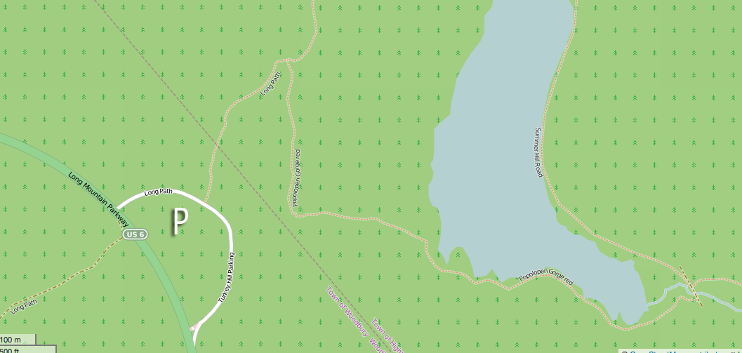
Turkey Hill parking area, with access to the Long Path, two shelters, the Torrey Memorial, and Turkey Hill Lake. Map © OpenStreetMap contributors
Do you need a lift to the trails? Can you offer a lift to a hiker? Leave such offers, or requests for lifts, on our Facebook page! We’ll try to make a connection.

Any way you can set up the ability to be able to pin your info with Pinterest?
Thanks.
Just did — thanks for the suggestion!
When I lived in the area back in the 1950s and 1960s I fished early mornings at many lakes. I was allowed to “sneak” my car in between some large boulders along the road. As long as the car was off the roadway and I moved it by 9 AM I was not bothered by the rangers nor did I receive any tickets. Is this still allowed?
Can’t do that anymore..Iron rails put up in place of the boulders.. we used to do the same.
Regarding your description of trails from the ORAK parking area on Gate Hill Road – I believe you would take the unblazed trail right to get to Upper Pound Swamp. And if you continue beyond Upper Pound Swamp, you come to the ruins of an old estate, before coming out onto Gate Hill Road east and down the hill from where you started.
If you took the unblazed trail left from Irish Potato, you’d end up at Beaver Pond Campground. Which is nice too.
Thank you for this post! My husband and I went hiking with our pup to the lake from Turkey Hill parking area yesterday and it was exactly what I was looking for! The water was clear and pleasant, and we will definitely be back.
I really love your feedback. Might you happen to know where would be the best place to park if I was wanting to reach Pine Meadow Lake? I may have about 20 cars in my group. I really would like to make parking easy for them 🙂 We are going to hike up to the mountain and spend all day up there.