Some weekends, you just want out of the concrete jungle. Here’s one way to get from New York (Penn Station) to Harriman (Tuxedo Station) and onto the trails. Pick up the new trail maps from the Trail Conference; the 2015 edition shows mileage between trail junctions.
Taking the train from New York’s Penn Station to the western edge of Harriman State Park sets you up for a sweet day of hiking, with lots of views, options for lengthening or shortening your hike, and a historic lean-to (in case you want to overnight).
Just remember you’ll have about .6 of a mile of on-road walking (or, take our shortcut*) to do before you reach the trail head. And then it’s an upward climb to get to the ridge above!
Get out and hike! The Ramapo Dunderberg Trail is accessible for New York City folk without cars; just take the NJ Transit/Metro North Port Jervis line, from Penn Station. Getting to Harriman State Park takes just over an hour via this route.
You’ll want to pick up the trail maps, either (or both) in their hard-copy form, or as digital downloads onto your smartphone. Worth every penny, and I think of these maps as a one-time fee for entry into the great world of Harriman hiking.
The map set (there are two waterproof, tear-proof maps in the set) is available from the Palisades Parkway Visitor Center (on the Parkway between exits 16 and 17), and from almost every nearby outdoor shop. You can order it from Amazon; you can also download it for your Iphone, which is a completely awesome alternative/enhancement, because the app will show you exactly where you are on the trail at all times (unless your phone dies!). Go to the App store and get the free App called Avenza; then go to the Avenza “store” within that app, and buy the maps. They’re also cheaper than the paper versions.
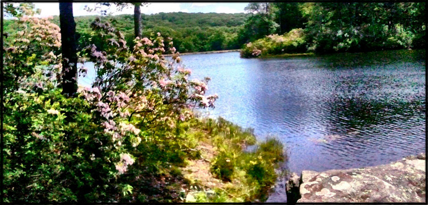
A piece of advice: any trail that’s littered with little black stars is a trail worth taking, ‘cuz those stars are carefully awarded to the best views only. So make sure you check out the Blue Disc trail on your hike from Tuxedo Station.
Get There:
Take NJ Transit (train) from Penn Station to Tuxedo Station (it travels on Metro North’s Port Jervis line). As of Sept 11, 2013, there is a 9:14 AM train that leaves Penn Station on Saturday morning and gets to Tuxedo in one hour. A train departs Tuxedo at 6:40 pm for Penn Station and arrives in just over an hour. Ten minutes after you leave Penn, you’ll arrive in Secaucus Junction, where you’ll transfer to the Port Jervis line. Get off at Tuxedo Station.
For supplies, go across the street to the deli to get some food for the trail. You should also be able to find the Harriman-Bear Mountain mapset there, in case you don’t have it in your hands or on your Iphone!
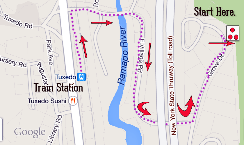
Then go back to the station, head north through the parking lot and parallel to the train tracks, to East Village Road, and turn right. Follow East Village over the tracks, over a stream, and under the NY State Thruway (it will wind around to the right, and you’ll go into a tunnel under the thruway).
Right after you emerge from the tunnel under the bridge, turn left at the “T” junction with Grove Drive and into a little residential neighborhood. Watch for the blazes. You’ll see tall spruce trees near the road on the left, and that’s where you should look for the start of the Ramapo-Dunderberg trail on the right. If you go to the white picket fence on the right, you’ve gone too far.
By the time you get to the trailhead, you’ve walked .6 miles from the station. And you’ll go, seemingly, straight up the side of the mountain.
Tip: Bring some extra water with you, and tuck it away in the woods at this point, for your return trip. It means less to carry, and you’ll appreciate it on the way back to the train.
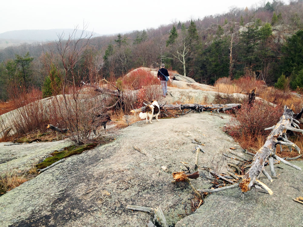
I suggest staying on the red-blazed trail until it meets up with the Blue Disc trail, which leaves from the left. Then, use the map above to plot your course (download the PDF), depending on how much time you have, how tired you are, and what you want to see.
If you have time, try to make either the old stone lean-to (“Dutch Doctor”) or the edge of Lake Sebago your destination for lunch, or even for the night.
Lean-tos at Harriman State Park don’t need to be reserved. They are used on a first-come, first-served basis, and are meant to be shared. They can accommodate up to eight people; you can also camp adjacent to the structures.
*The shortcut takes you over the train tracks, across the Lucky Bridge (a footbridge), over the Ramapo River, through a skate park, and under the thruway, where you’ll join a now-shortened road walk to the park. To take the shortcut, turn towards the town (rather than away from it) when you get off the train, and walk through town past the post office. Cross the tracks just past the post office, and soon you’ll see a little wooden footbridge over the river. Cross the footbridge to the skate park, and then use the driveway to meet up with the road through the neighborhood. You’ll go under the Thruway via a tunnel (you’ll see the blazes on the side of the tunnel), and take the first left up onto Grove Drive. Watch for the trail, going into the woods, on the right shortly thereafter.

Thank you so much for posting this. My family loves going hiking but we don’t own a car w/c often makes getting to these awesome trails kind of difficult.
Thanks, Liz! I’ll post more train and bus hikes. I’m also going to see if I can get support for a Metro-North shuttle from either Tuxedo or Manitou Stations — they used to do something like that. Enjoy the hiking. They are awesome trails.
I have tons of great photos to contribute. Not sure if you’re taking submissions or not. If so, what’s the best way to get them to you? Nice website, Harriman is one of my favorite places? Thanks.
Hi Glen: We love contributions. I wish we could pay at this point, but we’re not quite there yet. On the other hand, if you don’t mind that part, you can send photos to dan@myharriman.com. Thanks so much! And, you’re not a biker by any chance, are you?
Hi Suzy: Thank you for all the awesome information on this website. Are dogs allowed on the NJTransit/Metro North Port Jervis line? I have travelled with my pooch on Hudson and Harlem lines without a problem, but wanted to make sure Port Jervis will work too.
Hi Shruti: So far the answers I’ve gotten are “no”, and the official reason is that the Port Jervis line uses New Jersey Transit conductors & engineers and so operates under their rules, which are, “No Dogs” (except for service animals and very small, crated pets). I’ve asked both Metro-North and New Jersey Transit this question and their answers were the same. If I hear differently, I’ll let you know!
Thanks Suzy.I wish all trains were like Metro North.I guess Ill have to stick to Bear Mountain and Appalachian Trail. Are there any other trails reacheable by metro north that are worth visiting and scalable by pooches? Please let me know
Well, the Camp Smith trail is easily reachable from Manitou Station, and a dog could do that one. But if you ever plan a trip with your dog but can’t get to the west side (or any other trail), drop me a note — maybe we can pick up you and the pooches and drop you off somewhere else in the park. We’re there practically every weekend. And I do so much doggie transport, what’s another two muddy dogs in the hose-out Element?
I often think about ways to get people from the trains to different parts of the park — maybe a charter or a van or a Meetup group, or even something with a sponsor like LL Bean (who has a Meetup group that’s active in Harriman). I wish it were easier.
Thanks for your offer Suzy:) I might take you up on it someday. I do wish there could be some sort of meetup or easier transportation available.I would love to get out to Harriman more often
Hi Suzy!
I’m in the process of planning a surprise weekend backpacking trip for my boyfriend and I for his birthday and have found your website incredibly useful! I’m wondering if you have any suggestions for good multi-day backpacking routes in Harriman that we can access via Metronorth from NYC. We have a dog so unfortunately it seems like accessing the west side of the park via public transport will be difficult, and car rentals lately are exorbitantly expensive. Do you have any good routes you can recommend that we could access from say the Manitou station (or any station along the metro north lines that allow dogs)? We are fairly rugged backpackers so are looking for something challenging and ideally in the 20-30+ mile range! Thanks so much for your help!
Thanks for this article. I’m planning 2 night overnight backpacking trip from the city. I’ve done overnights with groups, this would be my first solo trip. If I get to the Tuxedo metro north station after work on Friday, can I hike to the Dutch Doctor lean to camp on Friday night? Or is that biting off too much in an evening?
Hi Katie: It will depend on what time you leave work, and whether you arrive on the 5:01, the 5:41, 6:09 or the 6:39. In Harriman the sun is setting closer to 8pm near the end of the month, so I think two hours to get to Dutch Doctor and set up before the sun goes down is enough time — it’s a little over three miles from the station to the shelter, and part of that is uphill.
You’ll be sharing the lean-to with others on a warm Friday night, I can almost guarantee, so if you’re uncomfortable with that, bring a tent or hammock for outside. Watch out for marauding raccoons! They’re hungry this time of year!
That sounds doable! I’ll probably set up camp after dark, but that’s what I’m expecting. I just want to avoid getting setting up my tent at 2AM (been there, done that). Do you think taking the train to Tuxedo is my best option, or is there another public transportation accessible camp site where I could start at backpacking trip on Friday night?
That’s really your best option, unless you would consider arranging for a taxi to pick you up and bring you to a different area of the park. But honestly that west-east hike along the R-D trail is so nice.
So I went to Harriman last week to scout out this trail before doing a solo overnight…. epic fail. I couldn’t find the trailhead! I seemed like I would have to invade someone’s yard. I wandered around confused for a good 15 minutes before giving up and hiking in another part of the park. I’m going back this week. I have your directions printed – any other tips for finding the trailhead?
This is terrible — I’m sorry this happened. I’ll update the post with more information, and pictures of where the trailhead begins, and a better map. So sorry about that.
Hi, just came across your site and thanks for all the info!
We’re looking to try the Camp Smith trail sometime in the next month from the train. Do you think a cocker spaniel, about 20lbs, could handle the terrain? We’re looking for anything train-accessible that wouldn’t involve a lot of rock scrambling.
Yes, if he’s in good health (and not 14 years old, with bad hips, like mine…). It’s a steep uphill, but you won’t be crawling over rocks or boosting yourselves up. Just make sure you don’t let him run onto adjacent Camp Smith (military) land, or too close to the edge of the nose. Enjoy the views!
Does the 9:14 train require a transfer, or is it direct? And does the 11:14 train still run?
I haven’t gone in years, but I used to take the PATH train to the Hoboken station where the Port Jervis train originates. Is that no longer an option?
Also, in Tuxedo, there used to be a little foot bridge over the Ramapo rivera few yards into a wooded area just across the tracks, which cut a lot of time out of the walk to the forest from the train. Is this no longer an option?
It used to be that on Sundays, there was only one train up, and one back about eight hours later.
Hey this is so helpful quick question if we get off a Tuxedo and do the loop can we also stay overnight and camp anywhere near the trail that’s close to Tuxedo? What do you recommend.
Hey! This page was SUCH a lifesaver for me and my friends. Just 3 kids looking for a great time and we’re so ready to get that fall foliage moment! Thanks so much for the tips. See ya on the trails, happy hiking babes xoxo
Just tried the hike today in the snow. Lot’s of fun, but with 8 inches of snow, I should have brought ankle high rubber boots! Takes twice as long in the snow. No one else out there, so if you’re looking for solitude just go when there’s snow and you’ll get it!
This hike was not bad, but I only saw red triangles and then blue triangles going back to where I started, which completed the loop. At one point the red triangles ended and we ended at an intersection with a white trail. We ventured into the white trail but then decided to go back where we came from as it was getting late. I’m not sure where everyone saw the red-yellow-Green trails!