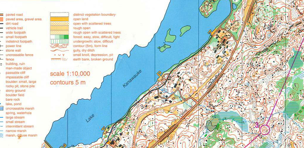
The map used in the only World Orienteering Championship to be held in North America. It was 1993, and the place was Surebridge Mountain, Harriman.
I know nothing about orienteering — navigating to a spot in the wilderness — as a competitive sport. But I was surprised to learn that the only world championship of this old sport to be held in North America took place in Harriman State Park, on Surebridge Mountain, in 1993.
The map used for this challenge is somewhat legendary among those who “orienteer” competitively.
(You can see a bunch of the maps from this event here, and learn more about the sport.)
And even if you have no clue what orienteering the sport entails, you can study the map at this link, study its key and get a pretty good feel for what it’s all about. And even if you’re not racing through the woods to get to the next spot on the map, it would be fun to try to follow these maps, on a weekend, just for the fun of it. Especially if you’re into maps. See how individual boulders are represented, stone piles, narrow marshes?
I’d love to find someone who can explain this sport to me, and — better yet — if they were there in 1993, so they could also explain why Surebridge Mountain was such a challenge. Leave a comment or send an email if you have some first-hand knowledge and wouldn’t mind an interview.


Very cool, this is similar to what Trail Runners do when race organizers do not provide adequate markings !!
That’s pretty funny, Gary. You could always do what they did on the Cornell Mine Trail….haha!
I see a lot of interesting posts on your blog. You have to spend a lot of
time writing, i know how to save you a lot of work, there is a tool that creates unique, google friendly articles in couple of seconds, just type in google – k2 unlimited content
But that sounds awful!
Hi Suzy –
I’m come across your site a number of times as I’ve taken a real liking to harriman in the last year. And it’s so funny – I’m a photographer myself. I was recently asked to do a shoot for NYT on orienteering in Harriman! I wasn’t able to per scheduling, and I haven’t checked to see if story has run yet, but was just laughing to myself when I came across this post. Hope you’re well! Love your Harriman site.
Hey Ramsay — That is funny, and I know your name & credit. Did you shoot for WSJ as well? Good to hear from you! (Any shoot in Harriman, you’d earn your assignment fee, that’s for sure!)
To find out more about orienteering near Harriman, contact the Hudson Valley Orienteering club, HVOrienteering.com
Spread the word! Everyone is welcome to learn about and participate in this navigation sport.
To find out more about the 1993 World Championships, one place to start is Orienteering North America magazine, an archived copy of which is available here:
http://online.fliphtml5.com/eicx/kfsw/
Janet T, Orienteering USA web content manager
(who found your blog post while searching for something else about the 1993 championship)