Park at the service area on northbound I-87 in Ramapo, New York, and pick up the trail from the southeast side of the lot.
Trails for the Curious
Two Saturdays ago I counted more than 100 cars in and on the road in front of the Reeves Meadow Visitor Center in Harriman State Park. It wasn’t Memorial Day weekend; it was just a brilliantly sunny day, one of the first hints of the coming summer, with comfortably warm temperatures teasing out the leaves of a lime-green forest.
I think there are a few reasons that spot is so popular: it’s one of the only discernible parking areas in the entire park, it’s got a kiosk trailhead that says to drivers-by “Hike here!”. And the trails that leave from behind the building are really, awfully nice.
Parking at the service area on I-87 north in Ramapo, you can follow the unmarked trail into the woods to join the picturesque trails of southern Harriman State Park.
But you can get to those trails almost as easily by leaving your car in the parking garage of the Ramapo service area on the New York State Thruway, and taking a little-used path into the park and toward the Hillburn-Torne-Sebago Trail.
This service area — with a Dunkin Donuts!* — backs right up to the park, and the path leaves from the lot and follows a short but steep trail to the top of a plateau, where the trail becomes a level walk through a beech forest.
I did this on a Friday afternoon, and even as traffic streamed north from the city to weekend destinations, and the cars were a little slow to move through the lot, there was more than enough empty spaces downstairs and up on top of the garage.
The trail leaves from the southern end of the lot, and you’ll cross the driveway in the back of the parking garage where the trucks sit and idle. Look for a telephone pole on the other side. There, between a large pear tree and the pole, a goat path leads up the hill and away from the service area.
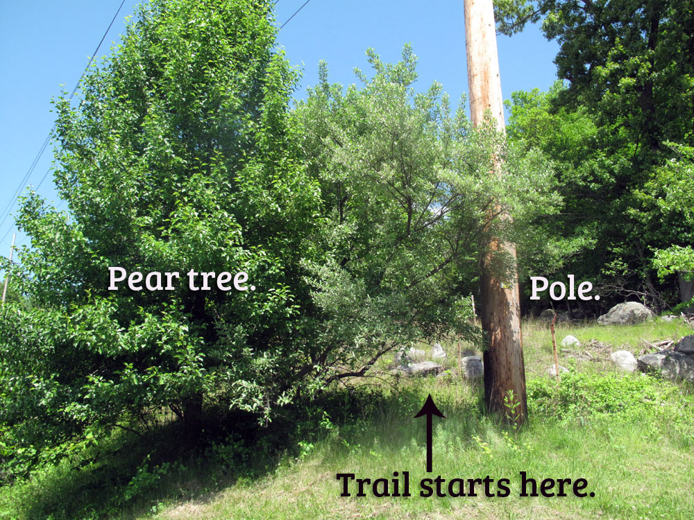
The unmarked trail leaves the service area from between a pole and an old pear tree.
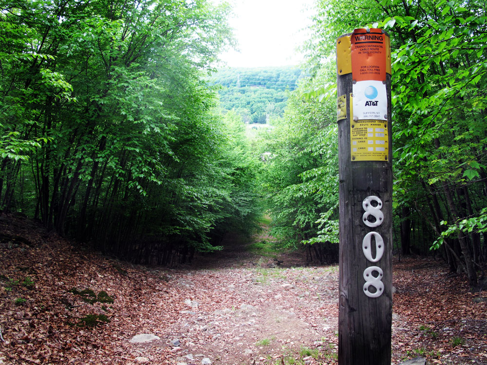
For a very short climb, you’re following the path of the AT&T Transatlantic cable (not the road to the power poles, a little further along). It’s a little stony underfoot, but at the top it levels off and you’ll find a comfortable and wide trail through the woods.
The thrum of the thruway soon fades into silence, and in about a mile, the trail will leave the woods road at a small cairn and descend into the woods, toward the sound of a stream (refer to your map app to avoid missing this turn).

Trying to avoid stepping on the snake (left), I almost accidentally stepped on the rare Lady Slipper Orchid (right).
And then the trail becomes a very lovely place to be. It narrows and winds a little, finally reaching a rushing stream with pools and runnels and the junction with orange-blazed Hillburn-Torne-Sebago trail.
I was surprised to see that this parking area is even closer to the vistas of south Harriman than the Reeves Meadow trail. It’s a good access point if you want to avoid the multitude of hikers at the beginning of the trails, or just take a different way in, for a change.
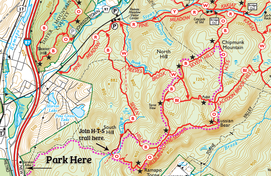
Following the garish pink-dotted trail on the map above to the main trails, you have a number of options for hikes of different lengths.
Some warnings:
- Because there’s a steep incline at the very beginning (not a scramble by any means, but it is steep), it’s not a good start to a hike if you have little kids or elderly adults.
- I recommend STRONGLY that you have the Avenza map app for your smart phone, and you’ve downloaded (for $5.99) the NYNJTC map** for the south section of Harriman (map 118). The trails in this area are unmarked, and many trails lead off from the main trail, and that can add up to a lot of confusion.
- The website for the Thruway authority states that no car should be left for more than four hours, so this is not for overnighters.
*Whither the lemon donut? Is it officially on the Endangered List, with the cinnamon and dunkin (which is basically the old fashioned, with a little nub sticking out the side)? Or worse? At least in this part of the country, i think the answer is, sadly, “Yes”.
**I don’t derive any benefit from promoting the Trail Conference maps, but you should get them if you don’t already have them, in both paper and app format. They’re a must-have for these trails.
